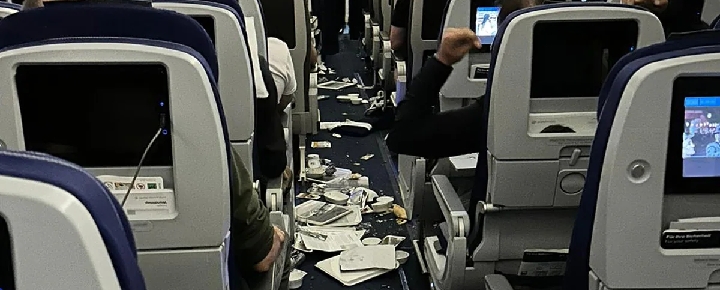
The initial NTSB report on Hawaiian Airlines Flight 35 is out, which will go down in the annals of extreme turbulence in-flight events. It resulted in at least two dozen injuries, of which six were serious. Two of those injured were crew members.
There’s also an implied safety message about keeping seatbelts buckled, especially when requested. Furthermore, the timing of the incident during the flight probably could not have been worse as you’ll see below.
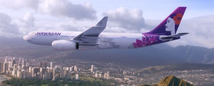
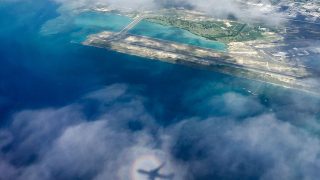
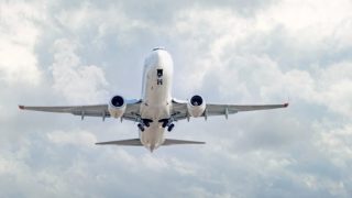
The incident happened on December 18, as the Airbus A330-200 widebody was approaching Honolulu. Perhaps ten minutes before it was to begin its descent, the pilot reported a vertical cloud shot up directly in front of the airliner.
Until that moment, the plane was flying uneventfully in clear weather and experiencing no turbulence, with none indicated on the aircraft’s weather radar.
According to NTSB, the cloud that resulted in the extreme turbulence, which caused a sudden drop in altitude and slightly damaged the plane, appeared without adequate time to change course. The pilot advised the purser, but only a few seconds before the event occurred, throwing some passengers out of their seats and into overhead fixtures.
Extreme weather and thunderstorm warnings at the time.
On the day this happened, we recall well that the Hawaiian Islands were in the midst of an exceptionally strong wind and rainstorm that was, even for Hawaii, highly unusual. Enormous brief wind gusts were occurring, at least on the ground. Not only that, NTSB reports that there was a National Weather Service warning for thunderstorms in the area at the time of the incident. There were, however, no reports of turbulence reported by other flights along that route.
NTSB’s weather analysis following the incident concluded that “There was an occluded frontal system with an associated upper-level trough moving towards the Hawaiian Islands. Satellite and weather radar imagery and lightning data depicted strong cells in the vicinity of the flight.
The U.S National Weather Service (NWS) had issued a current Significant Meteorological (SIGMET) warning for embedded thunderstorms with tops reaching FL380 over the region, according to NTSB. That was the altitude at which the aircraft was flying when the problem occurred.
What happened that morning at 38,000 feet?
According to both NTSB and Flightaware, the aircraft was still at its filed cruise altitude of about 38,000 feet, with the first officer in command of the flight at the time of the incident. The captain reported to NTSB that there was no indication of any issues until between 1-3 seconds before the event.
Passengers have reported a significant drop in altitude, along with the turbulence. While that makes sense, given other details of the injuries and damage, that was not included in the preliminary NTSB data, which is found in its entirety below.
The seatbelt sign.
The NTSB did not specify whether or not the seatbelt sign was illuminated at the time, although passenger and other reports indicated it was. It appears, however, that most of the injuries were related to those passengers who were non-compliant by either not wearing seatbelts or not being in their seats at the time.
Very bad timing.
When the incident occurred would have been just the time that passengers needed to re-stow cabin baggage and, if necessary, use the restroom one last time after the long flight and prior to the descent. In our experience, passengers are far more prone to move around at that time, with or without the seatbelt sign on.
Moreover, are we desensitized to the seatbelt sign at times, such as when the aircraft isn’t experiencing active turbulence or when time is pressing for the restroom or to prepare for landing?
We sense that this incident will serve as a reminder for Hawaii travelers and beyond about the seriousness and unpredictability of severe turbulence.
Please let us know your thoughts.
Report_DCA23LA096_106472_1_14_2023 1_16_02 AM
Get Breaking Hawaii Travel News

Hi:
I’ve been meteorologist forecaster for 38 years. What follows below is my opinion.
Elevated ocean surface temperatures over a broad area do provide energy for deep convection (updrafts) and the development of tall cumulus clouds. Tropical oceans tend to have more tall convective cumulus clouds than cooler oceans to the north or south because of that extra heat.
But unless a seamount eruption actually broke the ocean surface and spewed a plume of heat and moisture directly into the atmosphere (say, like the Tonga eruption last year), I don’t think volcanic activity heat would be concentrated sufficiently to create a dangerous storm cloud. Most of such heat would be dissipated in the ocean before it ever reached the surface.
Hi, thank you for posting this – I’ve been curious – the (reported) rapidity of the cloud plume’s formation seems highly anomalous, even in a severe thunderstorm. I did a (very) little research and discovered that 3-4 hours earlier there had been a 3.2 magnitude earthquake centered in the region of the Loihi seamount, a hydrothermal vent about 22 miles off the southeast coast of Hawaii. Local surface winds were forecast to be from the southwest and west that morning as the storms gathered. I’m wondering if a geothermal/hydrothermal plume could have heated the surrounding water enough to cause a moving microclimate event, with rapidly warming ocean temperatures driving a current of updrafts migrating north and east. Just a thought. Thanks.
I was fine as soon as we regained stability. But a lot of others weren’t. (Understandably.) I immediately told my wife that it was a good thing we were landing on an island, so no one would have a choice but to get back on the horse. Had it occurred over the mainland, that probably would’ve been the last time many of those passengers would ever set foot on a plane.
I will never be able to shake the image of a guy stretched out horizontally against the ceiling.
Once EMS finished addressing the injured and removing them to triage, the rest of us were able to stand up and get our things. At that point, the guy behind me was finally able to locate his phone. It had become lodged above the overhead bin! 😱
I’m seeing a lot of people looking over our shoulders after this incident. I only hope we have learned something from it.
I am that traveler that always watches the safety instructions. Since I fly HA from NY to Oahu, I plan for a nap and use a white blanket so the flight attendants can see my belt secured over my blanket.
I am grateful I was not on that flight.
On June 17, 2023, we would have been! That’s the flight we take twice a year!
We were always taught as kids to keep seatbelts on snuggly when sitting. For the last 50 years that’s what I do on airplanes.
When you have it loose around your waist, you will get more injuries during an incident like the Hawaiian incident. That’s why car seat belts have pre-tensioner which tighten when it senses an imminent collision. Snug is the key word.
thank you for the details. I will definitely think about putting my seatbelt the next time I fly
Good commentary. There is a great documentary online called “fasten your seatbelts, the truth about turbulence” on Fox weather channel. About 54 minutes long and highly recommended. The good news, aircraft are designed to encounter and survive even the worst of turbulence. The bad news, the number one cause of injury in non fatal airline incidents is turbulence sustained by non seatbelt wearing passengers and crew. About 58 a year. over half of those injuries are sustained by flight attendants.
Keep your seatbelt on when in your seat, and be extra kind to those flight attendants!
Aloha.
All of this technology for what? It failed when it was most needed.
You only got 1-2 seconds of warning. What are you going to do? Jerk the plane hard left to avoid the cloud and cause more passenger injuries?
I was a flight attendant for 25 yrs. Unexpected turbulence is always a probability. Also something known as clear air turbulence. I always keep my seat belt on. It’s not something to take lightly. I’ve been in the aisle during bad turbulence… you need to drop seat to the floor and wrap your arm around the nearest armrest. Also you can yell for seated and belted passengers to hold on to you.
This event could have been much worse and it is unfortunate that some got hurt. On the other hand, people (passengers) could be more responsible for their own safety.
I’ve been flying to Hawaii since 1986 and during that time I’ve only experienced 3 times where flights were disrupted, once by weather, once with hydraulic issues and once by electrical problem. You have to give pilots credit for being able to handle these events.
Don’t know how to initiate a new topic – or if I even can – but I am Soooo mad at Hawaiian Air right now… Not only have they doubled the points needed to book a flight, they are now charging a minimum of $102 to sit in the first 21 rows of the plane!!!