Bad timing + Weather Warnings: Hawaiian Airlines’ Incident Missed DetailsHawaii Travel News / January 14, 2023 / 15 Comments The timing of this Hawaiian Airlines mass casualty incident may also provide insight into what happened. Continue reading
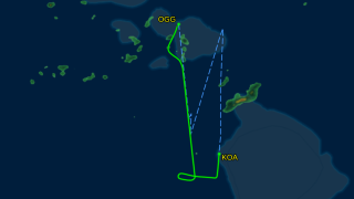
Three Hawaii Flight Incidents Spotlighted Amid Global Air Turbulence Surge May 22, 2024 / 10 Comments
Another Hawaiian Airlines Incident: Emergency Landing/FAA Investigation December 20, 2022 / 17 Comments