Visitors booking a Kauai helicopter tour for this summer are looking at price, reviews, and, maybe now, which company offers doors-off flights. They are not looking at whether the canyon they’re about to visit has any working weather cameras for safety. Most visitors don’t even know to ask.
The answer for now is there are no cameras, at least not yet, and not before this summer’s busy tour season starts launching from Lihue Airport.
Now, everything is about to change. New cameras will be going into the upper and lower Waimea Canyon. They are the same kind used by Alaska helicopter pilots since 1999, where weather-related aviation accidents dropped an amazing 89% in the seven years after they came online.
Kauai is planning to get them at the end of 2026. That puts the entire summer tour season outside of that timeline, on an island where fast-changing visibility has already played a deadly role too many times.
The 25-year gap on the Garden Island.
The FAA weather camera program began in Alaska, based out of Anchorage, where pilots face the same kinds of problems Kauai pilots know well: mountain weather that can change faster than it even looks from the ground. The helicopter safety system now includes about 300 cameras nationwide, and after the Waimea Canyon installation, Hawaii is expected to have 26 cameras, including seven based on Kauai.
The Alaska results are impressive. Aviation fatalities there fell about 50% between 2000 and 2009 after a group of safety initiatives, including those cameras, came into use. Hawaii has had a similar crash pattern and the same weather-driven visibility problems, yet has received none of the same fixes on the ground.
Kauai is only now about to receive cameras in the places where they may have mattered most for many years. The FAA is saying they should be operating by the end of 2026. That timeframe hopefully includes how everything on Kauai takes longer than planned. That leaves pilots flying this summer and perhaps longer without the same real-time visual help that Alaska pilots have had for over two decades.
For visitors, most, if not all, of the 2026 helicopter tours will still be taking place before this part of the new safety system is finished. The aircraft here may be modern, the operator may be highly experienced, and the views are incredibly spectacular. But the preflight weather picture over some of Kauai’s most difficult terrain is still not what it should have been by now.
What the cameras actually do for pilots.
The cameras are not complicated from a visitor’s perspective, which is part of what makes the deployment delay hard to understand. They are solar-powered, battery-backed units mounted on raised platforms, with multiple cameras mounted on a pole that capture 360-degree views of the surrounding terrain. Each is a compact unit, small enough to install on mountaintops and inside valleys where regular ground stations cannot reach.
They also include weather sensors that stream temperature, wind speed, and wind direction. Pilots can review a 10-minute video loop online before takeoff, giving them a current view of clouds, visibility, and weather changes along the route they are about to fly.
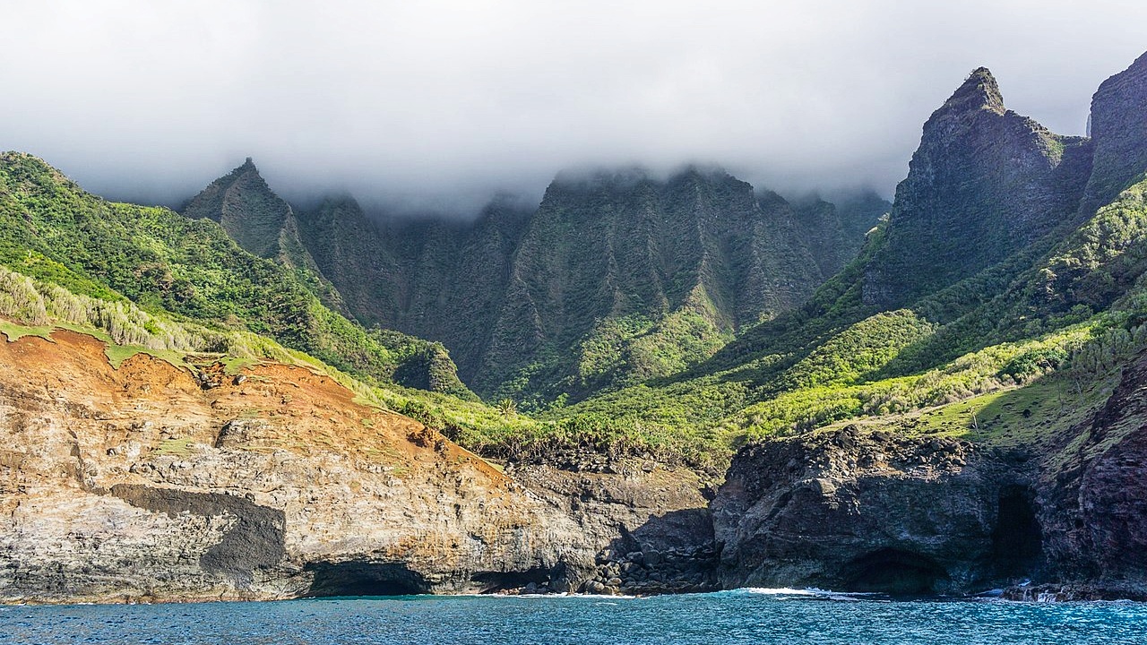
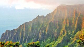
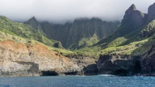
That is critical on Kauai because the issue is not just what the weather looks like at Lihue Airport. The problem is what it looks like inside the canyon, which is often dramatically different from what it looks like over the mountain ridges and along routes where clouds can move across the landscape in minutes.
Beat of Hawaii editors have flown this route. At one point, the clouds rolled in so fast it was genuinely frightening, and our highly experienced pilot abandoned part of the route entirely because the visibility risk was no longer acceptable. That is the kind of decision a pilot has to make in real time, often without the advantage of preflight weather information and imagery Alaska pilots have had for so long.
For a pilot preparing to leave Lihue, that kind of camera view may help answer the question that visitors are never asked: Is this planned route entirely flyable right now, or is it time to wait, change course, or cancel? That is not a small detail on an island where a clear view sometimes vanishes in moments once aircraft are near those mountains.
Four years after the NTSB asked for them.
The camera delay is not new. After the 2019 Safari Aviation crash near Nualolo on Kauai, which killed seven people, the NTSB issued its final report in 2022 and found that FAA delays in installing remote weather cameras in Hawaii contributed to the accident.
The pilot continued the tour into deteriorating weather, lost adequate visual references, and struck terrain. The wreckage was found on a wooded ridge about 3,000 feet above the Waimea Canyon floor and about half a mile from the designated route. Footage from another pilot showed visibility changing from clear to impenetrable within three minutes.
Kauai mountain weather does not deteriorate slowly. It can change while a tour is already in the air, and by then the choices become much more challenging than the decisions made before takeoff.
BOH has covered the broader crash record before, including the long-running pattern behind why Hawaii helicopter crashes keep happening and the more recent questions raised by Kauai helicopter crash flight data. The new Waimea Canyon cameras will soon help answer recommendations that have been made for years.
The pattern behind the delay.
This is not the first time Hawaii helicopter safety has moved slowly after people died. It is part of the same pattern BOH has been following across multiple crashes for years: FAA actions and industry promises that arrive too late to help the people who need them.
BOH has reported that weather is responsible for roughly one-third of helicopter crashes in Hawaii, which is exactly where the camera system should have become urgent long ago. The crash record on Kauai alone, including the Safari in 2019, the Robinson R44 in July 2024, and the Airborne Aviation crash off Kalalau in March 2026, has repeatedly built the case for these cameras.
From Kauai, helicopters are a complex issue. We have hiked the Awaawapuhi Trail at Kokee and experienced the helicopter density firsthand, with aircraft repeatedly moving through the airspace while visitors walk the ridgelines below. BOH has documented up to 25 flights per hour in Kokee airspace, and BOH editors live on Kauai with direct sightlines to helicopter routes that are part of daily life here.
Editor Jeff has also flown the Jurassic Falls Island Helicopters tour and reviewed it on BOH, so this is not written from the position that visitors should never fly. The question now is whether the safety system around those flights has kept pace with what Hawaii’s terrain, weather, and crash history demand.
That is also why the FAA’s separate handling of helicopter altitude questions over Kauai remains part of this. BOH covered the FAA proposal involving lower helicopter flights over Kauai, and the concern then was the same as now: federal decisions about Hawaii air tours often arrive slowly or after residents and visitors have already lived with the consequences.
What this plan changes for visitors, and what it doesn’t.
The Waimea Canyon cameras should clearly help pilots make better decisions before takeoff. They can show what is happening along a route, whether visibility is closing in, and whether conditions near the canyon differ from those at the airport. It may help an operator delay, reroute, or cancel a flight that might otherwise have launched with less than optimal information, and it gives pilots another way to compare what they expect with what is actually happening in the terrain ahead of them.
They do not help once a flight is already deep into fast-changing weather. They do not address mechanical or maintenance issues, pilot judgment, the doors-off question that has come up in separate discussions about Hawaii helicopters, among other things.
Kauai helicopter tours are sold as unforgettable, and for many visitors and even us residents, they are exactly that. This summer, one important safety tool is still missing from Waimea Canyon tours, even though Alaska has long had the same kind of safety system.
If you’ve booked a Kauai helicopter tour for this summer, would knowing that the new safety cameras aren’t yet operating change what you ask the tour operator before takeoff?
Lead Photo: © Beat of Hawaii.
Get Breaking Hawaii Travel News


We have visited the lower lookout over the canyon more than 30 times, and the upper lookout whenever the road has been open during our annual trips to Kauai. It has always amazed me how Quickly and dramatically the views into the canyon can change. It occasionally changes from completely clear (for taking great pictures) to totally fogged in with almost nothing beyond the safety fence visible. I have taken 2 helicopter flights and one bi-plane flight around the island, with all 3 entering the canyon. These cameras should help immensely, but with significant visibility changes happening in a few seconds, not even minutes, I believer there will still be some risk. But, there is also a risk in driving down a highway at 70 mph. The views from an aircraft are incredible.