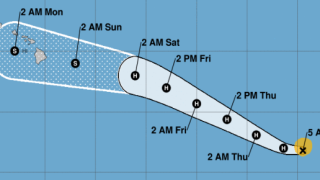
The entire state of Hawaii was in a complete frenzy this weekend, to prepare for potential damage associated with Hawaii Hurricane Douglas. As it turns out, most gratefully, the hurricane did not cause damage to Hawaii, and the potential for severe winds, flooding, and rain never materialized whatsoever. What did happen, was the extraordinary worry associated with planning for a major hurricane that might have struck Hawaii. And some huge expenses, both personally, and at Hawaiian Airlines.
What didn’t seem to make sense.
Yesterday afternoon, we started tracking the storm via NOAA radar as it passed the Big Island, Maui, Molokai, and Oahu. We were struck by seeing the storm veer north but the most dangerous energy was situated on the north side of the storm itself, while the islands were to its south. As the storm finally moved north then west of Oahu, we watched it move much further north and away from Kauai. All the while NOAA was saying there was a hurricane warning in effect. Then too, why last night were NOAA meteorologists making so many excuses about the forecast that they have predicted but that had not materialized. This all struck us as very odd, and somewhat concerning.
Why was Hurricane Douglas forecast so different than the actual storm?
No one can predict mother nature and that can’t be more true than when dealing with hurricanes. Looking back historically, however, we can see the hurricanes that have caused damage in Hawaii since the beginning of modern-day forecasting and tracking. None of them caused significant damage in Hawaii when they approached from the direction of yesterday’s Hurricane Douglas.
Only one of the prior storms on such an approach pattern, Hurricane Hiki, 70 years ago, did any damage to Hawaii. We’re anything but meteorologists, but it appears that by their very nature hurricanes coming on the north side of the islands have their power located in the north and west quadrants, which is not conducive to damaging the islands even when approaching at very close distances. That in spite of the fact that yesterday’s storm was closer to the islands than was Hiki.
That was very clear to us watching here, as the storm passed over Oahu and then Kauai last evening. On the other hand, hurricanes that approach from the south have caused the most damage and also have the most energy potential in their northern quadrant, which puts the greatest potential danger closer to the Hawaiian islands.
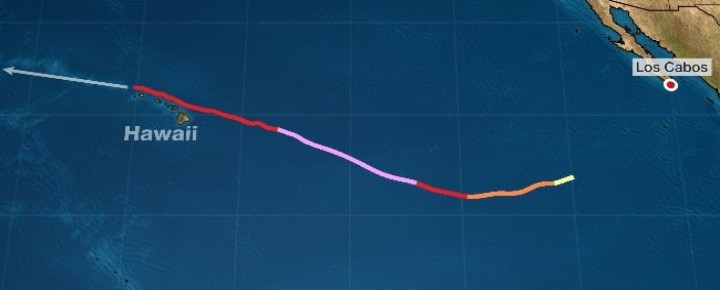

Hurricane tracking in Hawaii – 70 years starting with Hurricane Hiki.
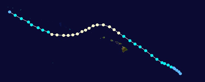

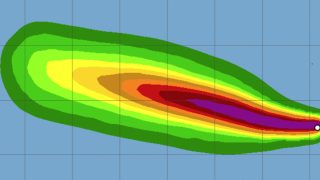
Thankfully, hurricanes here remain largely rare events. In modern hurricane tracking, Hurricane Hiki (track pictured above) was the first hurricane in Hawaii waters. That was in 1950 and it remains one of the wettest storms ever recorded in the US, following Hawaii Hurricane Lane (2018) and Hurricane Harvey (2017). While Hiki didn’t strike Hawaii directly, rain of 52 inches was recorded on Kauai and the Waimea River overflowed.
Since then, Hurricane Nina produced severe winds on Oahu in 1957, Hurricane Dot caused damage to Kauai in 1959, Estelle produced flooding and high surf on three islands in 1986, Iwa struck Kauai in 1982, creating a quarter billion in damage, followed 10 years later by Hurricane Iniki, which caused 3.1 billion in damage mostly to Kauai.
Hurricane tracking has been significantly upgraded over the years, starting with the Tiros 1 weather satellite which was launched in 1960. It still, however, has a very long way to go, based on what we experienced this past weekend.
We asked NOAA directly about their radar system on Kauai. We were told that it was nearly 30 years old, and for the most part only showed storms from the south.
Thus, last night NOAA acknowledged again that the storm’s radar tracking would become unavailable. Seriously? We should also mention that NOAA is still using Flash for its radar, and while they plan to change it, for now, only browsers with Flash can access the four Hawaii radar locations located on the Big Island (2), Molokai and Kauai.
Hawaiian Airlines moved 54 of its aircraft from Honolulu.
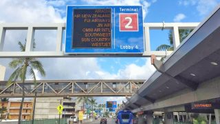
Hawaiian canceled all flights yesterday. They also moved their interisland B717 fleet (20 aircraft in total) from Honolulu to Kona to be out of harm’s way. Some of those aircraft, however, were kept in closed hangars in Honolulu. The 20 aircraft fleet of A330 wide-bodies was ferried to the west coast, as was the 18 aircraft fleet of A321 narrow-body planes.
We can’t accurately estimate how much this mess cost Hawaiian, but we’ll throw out a few numbers just for discussion purposes. Some of you may be able to help clarify the expense further. The nominal cost to operate the wide-body A330 fleet, according to planestats.com is in the range of $8,000 per hour. The cost to operate the narrow-body A321 fleet may be in the range of $5,000 per hour. That doesn’t include a plethora of additional expenses Hawaiian incurred to get the currently out of service planes ready. Plus landing fees, storage fees, etc. We’d guesstimate their cost for yesterday at no less than $5,000,000.
Sound off please. Thanks in advance for your comments!
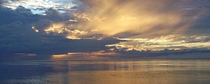
The lead photo is of 2018 Hurricane Lane. Douglas photo courtesy Weather. com.
Get Breaking Hawaii Travel News


Good points, but how would people have reacted if the hurricane had changed course (as hurricanes sometimes do) and wreaked havoc? “Better safe than sorry” comes to mind. And maybe adequate funding for NOAA would help solve some of the forecasting problems. NOAA scientists and staff are knowledgeable, dedicated and hard-working. But they can’t do magic with old equipment.
“Wrong Forecast Spared Islands / Shattered Nerves / Cost Hawaiian Air Millions.”
Seriously? 🙂
Was this supposed to be under the general heading of : “What went right with the weather reports”
I don’t understand how not being able to use an outdated browser extension to see a time lapse of a radar display that doesn’t cover the part of the ocean that the hurricane was in constitues a “wrong forecast” . The flash browser extension is rarely used anymore. thats why NOAA is taking it out of their sites.
There are also many other sources of info, and many are way more accurate than the island radar. I would recommend using these apps or sites in the future to get detailed weather info, no flash required :
Windy
Predict Wind.
Hawaii News Now
Also check out NOAA’s much newer technology, such as their GOES- 17 weather satellite images. It is in geostationary orbit 220 miles above the Pacific Ocean. It kind of like Hawaii having it own personal weather satellite, and it is only 2 yrs old. That where we get the detailed storm weather info from these days.
As a news and information organization, it might be advantageous to look for multiple information sources.
If you look on the local tv news site link below, you can find a very detailed graphic showing the storm track of Douglas. Zoom in to see the detail of the storm track past the islands.
.
http://www.hawaiinewsnow.com/weather/hurricane/
This is the same information that was presented on “Hawaii News Now” during the approach of the storm.
As of today is is still showing the compete storm track, from its beginnings off central America to its current state in as a tropical depression in the western pacific. It also shows that at two different times the trackline extended put the hurricane eye right over one or more of the islands. One was about two days out from what would have been a landfall on the Big Island, and then again when it was just north of Oahu and headed for Kauai. That part of track shows three data points for the center of the still category 1 Hurricane on Sunday night starting at 6:10 pm to 8:00 PM, that pointed directly at the top third of Kauai. If the storm had stayed on that course, the eye would have passed to the south of Princeville and Hanalei, putting that part of the island in the “dangerous semi-circle”. Thats where the windspeed at the eyewall of 85 MPH would be added to the speed of the storm moving across the ocean of 16 MPH for an effective windspeed on the surface of over 100 MPH. This is one of the events that made Honolulu TV newsman Keahi Tucker ( who is a Kauai born) so nervous about the potential for landfall on Kauai. If he had dismissed the possibility from one of these turns in the storm path and it had come ashore, imagine the consequences. If that was a wrong forecast, then I would disagree with your article. The only contention I have with the HNN broadcast is that viewers had to be very careful not to mix up the wind speeds at the storm itself vs the windspeed at various places on the islands away from the storm center, sometimes that was not easy to see.
Regarding “Shattered Nerves”, I saw none of that on Kauai, and heard of only people getting prepared with good humor here as the storm approached as well as by communicating with friends on the other islands.
Regarding the ” millions ” spent by Hawaiian Airlines, At your invitation, I took a look at the probable cost for HA to move their three types of planes in preparation for the storm. By my calculations their cost would have been no where near the $5 million dollar estimate mentioned in the article. For movement of 20 of their A 330-200’s and 18 of their A321’s to the West Coast using a 5 hour operating cost plus one hour for startup, and including the most current landing fees at LAX ( ie., for their midsize plane , the A 321 it is $5,101 per hour, including fuel, full crew, ( not a smaller delivery crew), insurance, etc and a calculated $718 landing fee) . For the estimated 10 smaller Boeing 717”s to make the hop to Kona, I used an hour of operating expenses, as many of that fleet were in use inter-island and still “warm” and to simplifythe landing fees for LAX. Weather routing and planning was supplied for by their operations departments. The total I’m seeing for the entire relocation of their fleet is less than $1.3 million. I’d be happy to share my calculations. Here is the punchline, the cost to replace one wind damaged Airbus 330 aircraft for Hawaiian Airlines is $238.5 million each. So for 0.5% of the cost of one plane, they can remove the chance of any of their fleet getting damaged. So I’m confused, why was this brought up as a problem in the article headline? This is the cost of doing business in the islands, and in any part of the world really, as weather gets worse globally.
Although I have enjoyed reading many articles on local stories on Beat of Hawaii, this was not one of them.
Mahalo,
Brian
Aloha Brian,
You did not factor in the cost of profits lost from ticket sales (back and forth) for the time period, and the “bottom line” (which seems to be the point being made) is that it was money that would Not have had to be spent/lost, in the wake of the economic disaster that is facing the airline/travel industry…Especially HAL who has been hit the hardest, by the economic impact of travel to the Hawaiian Islands.
Your mathematical skills are impressive, but clearly there is far more to this than questioning the precise profit/loss gain of HAL, which (even with your decent math skills) you didn’t manage to get exactly right either…
Mahalo
Right on the money, Jim R.
Perfect sarcasm level as well!
Well played indeed
Your article is incorrect ……….. There is no way of knowing exactly where a hurricane will land, come ashore, until it is too late to do anything about it.
Diane,
I live in California, I love Hawaii, I love Kauai and I hope someday to retire and live on the Big Island. I started praying that the Hurricane would bypass the islands, I watched and to me, it looked like at least Kauai was going to get hit directly. I am so grateful and thankful that God spared ALL of the beautiful Hawaiian Islands and the wonderful people who live there! What an answer to prayer! Aloha!
Teresa
Well…..to defend the weather guys….you can not trust a storm…but “Often” enough…lots of unnecessary preventions are done and are never utilized…yep lots of $$$$$$. That happens for many storms and many states. Always, thankful when they are wrong! Kinda weird how it totally veered around the island then came back in the path it was….weird…thank you Jesus!
BTW…I am totally appreciating all your info on the island during these crazy times. Prayers Hawaii lightens up and lets us come late September. Kauai is MY fave in all the world….will be sad times to miss our place, our “guys”, and the people…be safe!
Hi Debbie.
Thank you.
Aloha.
Thanks for the interesting article. There’s somewhat misleading comments about the NEXRAD doppler radar on Kauai. These NOAA radars were very sophisticated when initially built, and have continued to benefit from installation of new algorithms providing new capability. The radar display on an internet browser does not require Flash, maybe in the past. The central Kauai mountains are so high that yes, it’s true, there would need to be another radar on the north side of the island to cover that direction.
Hi Jon.
Thanks for that. We stated what we were told by NOAA. As far as we can tell, flash is still required and their website says that they will be migrating from Flash in the future, so not sure about that. It says, “The National Weather Service is in the process of migrating away from Flash. This page currently uses Flash; If it does not work on your browser, please click on the “Standard Version” link in the upper left of this page as a workaround for now.” We’ve only gotten it to play using flash ourselves, and on phone use the paid version of Puffin browser to run it.
Aloha.
Who care how much it cost Hawaiian airlines or anything else? The headline e to your story should be thanks that the hurricane veered north and spared those of us who live here damage. It could have gone the other way. Then you would have bemoaned losing all those tourist dollars because that is truly all you care about. So be happy your vacation destination wasn’t decimated instead of complaining about NOAA.
I live Westside Kauai, put Baby Yoda in my North Facing window, then went to bed.
Woke up, Douglas gone and Baby Yoda sleeping !
All good!
Wow Dawn,
Pretty harsh comments.
Hope you have a better day.
Sounds like maybe Neil Ferguson’s crack team at the Imperial College of London has gotten into the Hurricane forecasting business, too!
Right on…..very well stated, not just for Hawaii but the rest of the USA as well!!
I am so happy the dire hurricane predictions didn’t come to be but cannot help feeling sorry for Hawaiian airlines and I understand your frustration with NOAA. I am glad you are all safe and the islands spared!
Hi Nadege.
Thanks as always. Side note – interesting news about Trudy’s move.
Aloha. R/J
I am so happy for Trudy! She feels safe and comfortable in her new environment! She is happy!
I am missing the islands terribly!
Hi Nadege.
Hopefully we can meet up sometime soon.
Our best until then.
Aloha.
“I believe in science, I believe in data, I believe in models that predict weather, climate and economic disaster. I believe the coronavirus death rate is not like a flu it is a pandemic”. Repeat again. Perhaps a little less blind faith in the “so-called” experts and a little more calm common sense would be useful in the times we are living in. The world we live in is very complex and the “so-called” experts never even admit when they are wrong. Why is there never accountability in the public sector experts? Over half the covid deaths have been in nursing homes. Who in public health is responsible for our elders? Will they have to answer why steps were not taken to quarantine our most vulnerable senior citizens when all the “data” and “science” from Italy demonstrated deaths were primarily those over 70. Please ask yourself if the damage done by unemployment and drug abuse from the shutdown of “living” might cause more death and suffering in Hawaii than the virus ever could have?
Right on…..very well stated, not just for Hawaii but the rest of the USA as well!!
Oh, those experts again! Let’s just make up our own ‘data’.
The first really good news in a long time! The islands and the people were spared from the hurricane. Give thanks!
The forecast wasn’t wrong, though. The storm tracked within the forecasted range. No forecaster that I’m aware of said landfall was a certainty. Weather forecasting technology does not exist to determine whether a hurricane or other storm will hit a very specific spot, like a relatively small island chain, or narrowly miss it, so it is better to be prepared than not.
I awoke SO GRATEFUL, in my Kauai bed this morning. What if…when the storm started skirting north of Hawaii an incredible response to united prayer was realized?
I watched the reports all day yesterday also and it sure looked, to my untrained eye, like Oahu and Kauai were in the crosshairs. I hold nothing against the weather forecasters. I have never lived in a place where the forecasts were 100% and my understanding is that when a storm brushes up against land it can act in unexpected ways. Mahalo to NOAA, our leaders and all those who made their best effort to keep us safe this weekend. The exercise in preparedness was a good reminder.
Hurricane forecasting is not an exact science hence forecasters tend to err on the side of caution. Had they said that the storm would pass North and do no damage and instead it turned west and hit the islands, what would you be posting?
Notoriously, hurricanes can fishhook at any moment. There are plenty of examples. The Navy used to regularly move aircraft out of places such as Pensacola, Fl. based on similar data.
If Hawaiian AL had taken a hit from the hurricane, they would gladly pay the number you mentioned not to have. The long term damage to to the community is the motivation to be very cautious. The long term damage to places like New Orleans and Houston are great examples.
I personally am very relieved things turned out as they did. Hawaii is a very fragile environment these days. Thank God it was a good outcome.
Well, what do you think it would have cost Hawaiian to have aircraft out of service due to storm damage? Better safe than sorry!
Thankfully Hawaii was spared! I am guessing posting a story link on this topic would not be ok. A researcher named Dr. Ying Chen from Lancaster University recently published a research paper about why weather reports to include hurricanes have been less accurate. He attributes it in part to diminished flights due to Covid19. Meteorologists only gets so much data from radar. They use data from many sources in making forecasts. The 2 most useful sources are aircraft and cruise ships for over water. On land additional weather stations/spots can be set up or additional weather balloons can be launched. While there are still buoys, their accuracy isn’t dependable for a variety of reasons.
I’m not a meteorologist. I just read a story about this today and thought I’d pass this along. 🙂
Thanks! I hope this post doesn’t go against the rules.
Hi Olga.
Thanks. Very interesting.
Aloha.
Mahalo for this article. I live in Kailua-Kona on the Big Island and was supposed to be visiting Oahu this weekend. Unfortunately, Southwest decided on Friday morning (4 hours before my outbound flight) to cancel my Sunday return flight (and all Sunday flights) due to the forecasted hurricane. I was not able to stay until Monday because of work and there were no options for a Saturday afternoon or evening return, so I was forced to cancel at the last minute. I was surprised and a little frustrated at the time that SW made that decision to cancel so early but I can certainly understand and respect it. And while it was a huge disappointment to miss my trip, I’m so glad our islands were spared from any major impacts of Douglas and that I was not stranded for an extra day away from home.
Hi Marci.
Thanks.
Aloha.
Loved your expose’! Incompetent, pathetic, hysteria-inducing bungled forecasts !
How many thousands of residents took time off from work (lucky to have work now), and spent hundred$ on supplies, equipment, generators, etc. “Crying wolf” will have many ignoring the next warnings. We could have used a few inches of rain: only got 1/8″, in Volcano.
Hi John.
Thanks.
Aloha.
Thanks for putting it so simply, John W!
I couldn’t agree more!
My phone notification siren woke me up here on the north shore of Kauai @ 11PM Saturday night. Then wailed again a few minutes before noon on Sunday, to explain it would be followed -by an extremely long lasting Warning Siren blasting for what seemed like 5 minutes in my neighborhood. All to ‘alert’ me to a Hurricane warning for arrival approximately 24hrs, and 12hrs respectively!
I would have rather they waited until landfall actually began (supposed to be 2-3AM Monday morning) to wake me up… because by the time it was supposed to arrive here onshore, I might have just gone right back to sleep and ignored it, if another siren went off then… and I don’t know if I could ever find a better example of ‘crying wolf’ syndrome in practice. I have no idea how to react to a warning siren anymore. And I have no faith in local news accuracy of reporting any longer. Even after local news spent hours of reporting on excuses as to why they “nudged” the maps & numbers for the sake of “safety”, that just further expose how hysterical they become for advertisers dollars. I woke up Monday to a small puddle and no sign of even a strong breeze…
I too spent all day yesterday preparing and now I have to put everything back! Ugh!! HOWEVER, I appreciate the efforts of news teams, CPHC, NOAA and other government agencies to keep us informed and protected. They did a great job and all of us should be grateful and not critical of their efforts or blame them for how people or businesses responded to the information provided. Thanks to all mentioned above. Please keep up the good work!
Hi CJ.
Thanks.
Aloha.
your decision to belittle forecasters for this NEAR MISS is ill advised. better for them to miss being cautious than for the untrained to become experts in their own minds. over and over the meteorologists explained the “cone of uncertainty”. you ignore that explanation. looking back, the eye of douglas never left the cone. YOU should apologize, and read about the cone.
Thank you for expressing my sentiments. I was holding my tongue, but very annoyed at the tone of this article. The author clearly likes to sensationalize and stir up bad feelings toward Hawaii officials. Blaming the weather on them now?!? Hawaii prepares for EVERY hurricane that approaches the islands no matter from which direction. Having suffered through two, I would not want anyone intelligently guessing as whether we should prepare or not.
This report sounds more bothered than relieved. We should demand better information from everyone beginning with the governor.
It sounds like it wasn’t the wrong forecast, it was the safe forecast. The islands have been there for millions of years. Comparisons to the last 50-100 years or even the last several hundred years is unrealistic. That time frame is a blink of the eye as far as mother nature is concerned. Certainly the islands have taken a hit from every point on the compass. Better to count your blessings and consider this a dress rehearsal. It’s only a matter of time before the real deal finds it’s way back to Hawaii. Just happy no one was injured or worse.
I’m a commercial rated pilot as part of my rating we must study and then pass an examine as it pertains to weather. To this day predicting the path of a Hurricane like Douglas is an educated guess at best. I along with several other amateur weather buffs we tracked Hurricane Douglas for several days. Using historic weather patterns and barometric pressure readings none of us could make a definitive prediction on where Douglas would make land fall. We held our breath and hoped for the best and the best happened. So instead of moaning about should a could a would a be thankful for the results.
Glad everything went better than thought.
I always say that Meteorology is the only career that you can be wrong everyday and still have a job.
I’m thankful that the forecasted storm never materialized.
Now we can all go back to wondering what’s next with the governor and COVID-19.
Great..
Mahalo to Beat of Hawai’i, you’re the best 🌺
Hi Pam.
Thanks so much. We’re concur completely.
Aloha.
Brought to you by the same people who are predicting Global Warming and/or eminent Climate Change which ever you would like to call it.
Watching the forecasts from here in Chicago, your storm was sometimes forecast as a tropical storm and other times as a Cat 1 (lowest level) hurricane. But the visuals told a different story! The evening news graphics showed a massive storm border in yellow then orange shades, and continuing inward to bright red, blood red, then blacks and a very evil looking dark purple center. But the thing is, those colors all are chosen by some software developer somewhere! Why blood red and dark purple? Because that’s what the developer thought would look coolest. It also looked scariest, though I can’t say that was the motive for the color choice. The same thing happens with coronavirus: we have a epidemic that makes some people horrible sick, but leaves most with zero or mild symptoms and kills just 0.2 percent of people infected. But the colors chosen by graphic artists for TV images are the same scare-us-****less colors: blood red, with huge images of animated Covid particles. Follow the numbers and the science, NOT what TV news wants us ti believe.
Lots of us were praying for the Islands — I’m saying YAY Universe!
Aloha! Overlooking Kahului harbor we were listed as the arrival point on Maui. With lanai living and dining rooms, not enclosed, we were consumed with preparation. All without regret. We lived in Austin when Katrina hit and had gone to sleep fully assured it would make land in Georgia or South Carolina because Atlantic storms “always ramp up as they hit the warmer water and head north”. No one in a Gulf state received warning. And then just a day prior to Douglas we watched as Texas suffered a second land strike just hours after the first. It was Aristotle would said “We must study the accidental to acknowledge it cannot be predictable.”
PS Today the trade winds are stronger than any of Douglas
Hi Lynda.
Thanks. Yes trade winds are back.
Aloha.
Your headline “Wrong Forecast….” is very unfortunate and erroneous. Forecasts were made with as much insight and foresight possible. In actuality we were fortunate that Hurricane Douglas was kind to Hawaii, especially since we are undergoing many adjustments due to COVID-19.
Hawaiian Airlines chose to do what they did. Just as homeowners boarded up and supermarkets closed early.
Your headlines were insensitive and inaccurate.
Silly! No one can predict completely accurately what Nature will do as is evidenced by our current COVID situation. Better safe than sorry right? It was close and as much as could be predicted. We are way too accustomed to things going completely our way lest we have a hissyfit! This was not another bomb headed for Hawaii situation, now that was a reason for complaint.
Can’t win either way. HUMANS!!!
As a frequent visitor to Kauai and also a resident on the Texas Gulf Coast, I could see that as the day went on Sunday,this was not going to be much of a weather event. We are always hoping to avoid the quadrant that is to the right of the line of movement (usually NE quadrant) and we refer to that as the dirty side of the storm. That quadrant was going to be north of the island and unless the storm was a Cat. 4 or 5 with a huge problem for the right or north side, nothing much was going to happen on the south side of the line of travel. I can see how storms coming from the south and aiming at the west side of the island would be a real problem by putting that NE quadrant over the main part of the island but that was not the situation with this storm.
The other issue that we experience here in SE Texas is that the news media loves to cover and/or hype these storms because of the ratings that it brings them. Look up the results of the Hurricane Rita evacuation when the TV news people had predictions of water reaching downtown Houston. I later saw where someone posted a picture of his plastic deck chair that had flipped over as the total result of the storm.
The NHC charts from Sunday afternoon showed that hurricane force winds were not going to hit Kauai but HNN was still talking about it hitting the island.
Hi Donald.
We didn’t get into the whole media aspect but concur with your observations.
Aloha.
Is there no satellite tracking of weather systems available in the islands?
One thing to consider about the inaccurate forecast is that in recent years commercial aircraft and cruise ships have become an important source of the weather reports that go into weather forecasts. Because of the pandemic there are far fewer of those reports and I suspect that in an isolated location like Hawaii that might have a significant impact on accuracy.
Thank goodness Hawaii was spared! I cannot imagine your comments if hurricane had hit the islands! Shocked at your outrage.
Congratulations! You just witnessed the fallacy of the global warming alarmists claiming that the computer models can tell us what the temperature will be in 100 years within several tenths a degree when the reality is that the best and most powerful super computers that are used by the NWS STILL cannot give an accurate track for a hurricane even a single day out let alone several days or even a week out! The weather on planet earth is just too dynamic a system for even the best computers to be able to model and predict!
What a relief! Thank you for the update.
I wonder if you might write a report of what life has been like for the locals during the pandemic in terms of the lack of tourists. Obviously it is creating a financial hardship for many, but it seems that there must be positives as well ( e.g. so much less traffic).
Thank you!
Hi Brenda.
Thanks, and yes we will be doing that.
Aloha.
Aloha BoH friends! I say don’t ask why, simply say ‘mahalo’ and move along! Never look a gift horse in the mouth – or in this case a mistaken hurricane forecast in the eye! 🌺
Hi Tea.
Thanks.
Aloha.
Aloha,
I say that’s one of the biggest problems the islands suffer… to just say ‘Mahalo’, and not question – ie. the falsification of forecasting that preempted al local cable programming over the weekend.
I could literally watch local news forecasters declare 105mph expected wind speeds, at the same moment the NWS, NOAA, and associated apps all declared 35mph forecasts for the exact same time & location. News here is becoming a farce, and it’s time to start asking why a lot more often.
Mahalo
Hi Michael.
Thank you.
Aloha.
This was not a “gift”. Everyone should know by now the typical tracks of hurricanes and the fact that they usually deflect off Mauna Kea and Mauna Loa to the North to colder waters and dissipate. I have watched them for over 50 years and was never worried about This one. There is a lot of stupidity being exhibited in the Islads these dats.