Hanalei Bay is closed again on Kauai, and visitors walking onto the sand are asking the same question Kauai encounters every time it rains. The water may not look terrible. Some surfers may already be out. Someone may say the advisory is probably old by now, while someone else warns that the bay is not safe even when it actually looks fine. The closure does not always extend to the rest of the north shore, and visitors trying to make sense of it on the spot are often working from the wrong information.
Why clear water can still be unsafe.
The visible brown water usually clears faster than the contamination itself does. Sediment settles, and sunlight returns. The bay can start to look normal again before bacterial levels return to safe levels. The ocean often looks inviting from the sand at Hanalei, while runoff from streams, cesspools, and storm drains has not fully flushed out.
Some Kauai residents use a rough rule of thumb after a major runoff event: two to four full days of dry, sunny weather before treating the north shore as recovered, and longer if the rain keeps coming.
The Kauai beach question visitors ask every time it rains.
The question that surfaces at the beach also surfaces on Kauai community pages within hours of every advisory, does the warning still apply if the water looks clear, and the answer rarely comes from any single source. Some locals say clear water means fine. Others say bacteria are invisible and can stay elevated long after the brown color fades.
Visitors posting photos from Hanalei get split answers because the iconic bay rarely matches what people expect contaminated water to look like, and that contradiction is part of what keeps the same question coming back every storm.
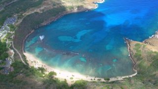
The closures themselves repeat on a predictable rhythm. Heavy rain sends runoff into the Hanalei River and into the bay; the advisory goes up, and the rest of the north shore may or may not behave differently depending on intensity and which beach. Today’s closure, which affects all North Shore Kauai beaches except Anini, is just the latest in a pattern Kauai residents have seen for decades, and it is the same pattern visitors will face on their next trip.
What brown water advisories actually cover on Kauai.
Brown water advisories on Kauai are issued by the Hawaii Department of Health Clean Water Branch and reinforced on the ground by Kauai Ocean Safety after heavy runoff events that carry bacteria and other contaminants from the mountains to the ocean.
On the north shore, those advisories often focus on Hanalei Bay because the Hanalei River and other drainages discharge directly into the coastal waters where visitors swim. Hanalei Bay closes for swimming and ocean activities, warning signs go up, and other north shore beaches with their own rivers, reefs, and drainage patterns may or may not stay outside the advisory zone depending on the event.
Visitors can call the Kauai Ocean Safety Bureau at 808-241-4984 for the most current information, and Ocean Safety also directs the public to SafeBeachDay.com for posted conditions.
Hanalei has appeared on national lists of water quality concerns before.
That includes our earlier coverage of why three Hawaii beaches ranked most polluted in the U.S.. That history helps to explain why many residents react strongly when visitors ask whether it is fine to swim simply because the water looks better. For those who have watched this cycle for decades, the advisory is not just a sign on the beach; it is the public version of a problem that begins far upstream.
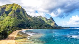
The North Shore is not a single water body.
It is a series of distinct beach systems with their own watersheds, reef structures, and river relationships. Anini sits inside a long reef-protected cove with a smaller watershed separate from the Hanalei River drainage, which is why it often avoids the direct discharge that turns Hanalei into the center of the advisory. Larsen’s and Kahili sit east of the Kalihiwai system. while Kauapea is reef-fronted. Tunnels and Haena sit west of the Hanalei drainage with their own runoff exposure. Each beach is different during a runoff event.
Where Kauai visitors with a north shore booking actually go.
Residents on Kauai adjust quickly when the north shore closes after storms because there are workable alternatives. Poipu Beach, Brennecke’s, Lawai, and Salt Pond sit in very different drainage systems that, while they have their own concerns, are usually outside the north shore runoff pattern.
For visitors staying in Princeville or Hanalei, that can mean flipping the trip around rather than losing beach time, with south shore beach days moved up and Hanalei saved for later once the water clears.
Depending on traffic, the drive from Princeville to Poipu is usually about an hour, short enough to make an alternate beach day work. For those heading to Kalalau and the Napali Coast, those trails are entirely separate from the beach advisory itself, but the same rain that closes Hanalei can raise stream crossings and create significant trail problems. Visitors are wise to check trail conditions separately before assuming that a beach advisory has nothing to do with their hiking plans.
If you have been on Kauai during a brown water advisory, what did you decide to do?
Get Breaking Hawaii Travel News