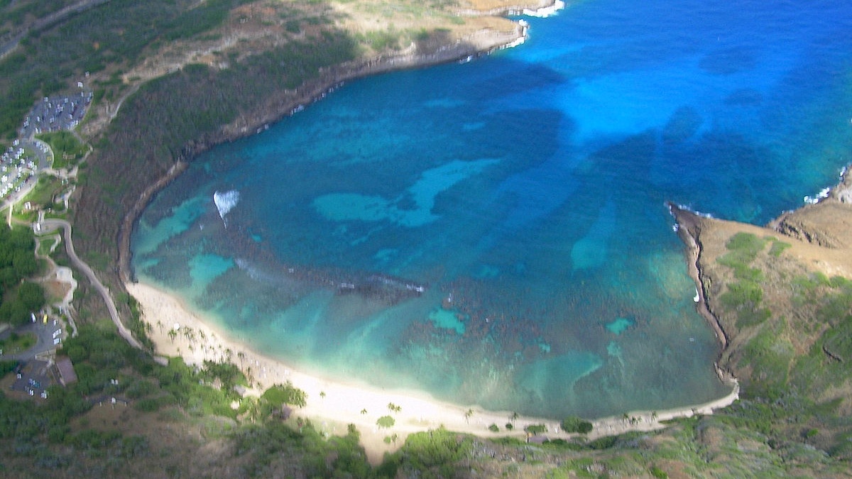
The search for a father and his 16-year-old son, visitors from South Korea, was suspended this month after they disappeared near Oahu’s Hanauma Bay Ridge Trail, which starts in the Koko Head District Park. This hike begins on the ocean side of the Kalanianaole Highway and is not to be confused with the Koko Head Crater Trail.
Officials have not released the names of the two who are missing, and the loss is a tragic reminder of how quickly Hawaii’s coastline can and does become dangerous.
What is striking beyond the tragedy itself is the place where it happened. It’s something many visitors never realize until they are already there. The official Hanauma Bay Ridge Trail is not the documented hazard. The danger begins when hikers leave the marked route and head toward an unofficial path that descends to the shoreline and the area known as Rock Bridge. That may sound small, but it is precisely why officials have responded to repeated rescues and fatalities there over the years.
The trail and the shoreline are two very different places.
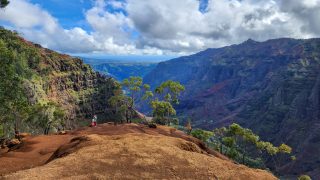
Many visitors hike to the summit of Kuamoʻokane before ending at the west edge of the ridge. There are sweeping views of Hanauma Bay and Koko Crater, the southeast coastline, and the open Pacific. It’s spectacular. The established route is still steep, hot, and physically demanding, but it is one many visitors hike without ever continuing beyond the ridge.
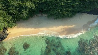
The confusion begins at the summit. From there, another path continues beyond the official trail and drops toward the back side of the coastline. That route leads to Rock Bridge, a natural rock formation outside Hanauma Bay Nature Preserve that has become a popular destination thanks to social media and online photos.
Honolulu Ocean Safety says the risk changes dramatically right on that descent. The shoreline below features steep cliffs and powerful ocean surge that can sweep people into the sea even when surf conditions do not appear to be extreme. Ocean Safety officials have said crews have seen people swept from that area over the years, making it a location with a documented record of incidents.
Two people have died there in recent years: a 64-year-old man swept into the ocean in February 2018 and a 56-year-old woman near the rock bridge in June 2020.
Why visitors often underestimate the danger.
Part of what makes the area deceptive is how ordinary it can appear from above. The continuation of the trail looks like it simply leads to another scenic viewpoint, and the rock bridge itself has become a popular image shared on Instagram.
What those photos rarely show is how exposed the shoreline becomes as hikers rapidly descend. Waves rebound off the cliffs, ocean conditions change very quickly, and there are few options if someone loses footing near the water.
Unlike a beach where waves spread across sand, this coastline concentrates ocean energy against a lava rock with steep cliff faces. Even experienced hikers may have little familiarity with those conditions, especially if they are visiting Hawaii for the first time.
The safest choice is also the most rewarding one.
For most visitors, the views from the official summit are the destination. They include panoramic vistas of Hanauma Bay, Koko Crater, Sandy Beach, and the southeastern coast of Oahu without requiring anyone to descend toward the shoreline.
If your goal is this dramatic coastal scenery, Oahu offers several legal and well-established alternatives that stay on maintained trails, arguably far safer. Diamond Head State Monument remains one of the island’s classic hikes and a BOH favorite, while the Makapuu Point Lighthouse Trail offers sweeping ocean views along a paved route that is far more suitable for most visitors. The unofficial shoreline route, however, simply offers no margin for error.
What officials recommend before you hike.
Emergency responders regularly remind hikers to stay on established trails, know their physical limits, bring enough water, and avoid hiking alone. The Koko Head area has little shade, temperatures climb quickly during the day, especially in summer, and cell service should never be treated as a substitute for good advance planning.
If conditions look the least bit questionable near the ocean, the safest decision is to turn around. Hawaii’s coastline often looks calmer than it actually is, particularly along rocky shorelines where swells can arrive without adequate warning.
These recommendations reflect lessons emergency crews continue to repeat after responding to incidents. We have written before about the gap between trails that appear accessible on social media and the realities hikers encounter once they arrive, including closed routes, unofficial paths, and exposed coastlines where a short detour can lead to something very different from the hike visitors thought they were taking.
For most visitors, the safest choice is also the simplest one. The official trail delivers the views people come to see of Hanuama Bay and Koko Head; the unofficial descent toward Rock Bridge adds risk without offering any additional scenery. Stay on the marked route, skip the shoreline below, and you will have seen the best and safest of what this hike offers.
If you have been on the Hanuama Bay Ridge Trail, please share your experience in the comment section. Mahalo!
By Rob and Jeff, Beat of Hawaii.
Some of the most meaningful parts of Hawaii are the ones visitors walk right past without knowing they are there. We’ve spent nearly 20 years finding them firsthand for BOH as full-time Hawaii residents reporting on travel, culture, and island life, and telling you what they mean for your trip. Join us →
Get Breaking Hawaii Travel News