64 thoughts on “Wrong Forecast Spared Islands, Shattered Nerves, Cost Hawaiian Air Millions”
Dave R
Good points, but how would people have reacted if the hurricane had changed course (as hurricanes sometimes do) and wreaked havoc? “Better safe than sorry” comes to mind. And maybe adequate funding for NOAA would help solve some of the forecasting problems. NOAA scientists and staff are knowledgeable, dedicated and hard-working. But they can’t do magic with old equipment.
Was this supposed to be under the general heading of : “What went right with the weather reports”
I don’t understand how not being able to use an outdated browser extension to see a time lapse of a radar display that doesn’t cover the part of the ocean that the hurricane was in constitues a “wrong forecast” . The flash browser extension is rarely used anymore. thats why NOAA is taking it out of their sites.
There are also many other sources of info, and many are way more accurate than the island radar. I would recommend using these apps or sites in the future to get detailed weather info, no flash required :
Windy
Predict Wind.
Hawaii News Now
Also check out NOAA’s much newer technology, such as their GOES- 17 weather satellite images. It is in geostationary orbit 220 miles above the Pacific Ocean. It kind of like Hawaii having it own personal weather satellite, and it is only 2 yrs old. That where we get the detailed storm weather info from these days.
As a news and information organization, it might be advantageous to look for multiple information sources.
If you look on the local tv news site link below, you can find a very detailed graphic showing the storm track of Douglas. Zoom in to see the detail of the storm track past the islands.
. http://www.hawaiinewsnow.com/weather/hurricane/
This is the same information that was presented on “Hawaii News Now” during the approach of the storm.
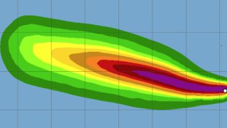
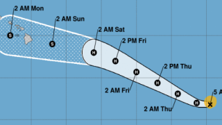
As of today is is still showing the compete storm track, from its beginnings off central America to its current state in as a tropical depression in the western pacific. It also shows that at two different times the trackline extended put the hurricane eye right over one or more of the islands. One was about two days out from what would have been a landfall on the Big Island, and then again when it was just north of Oahu and headed for Kauai. That part of track shows three data points for the center of the still category 1 Hurricane on Sunday night starting at 6:10 pm to 8:00 PM, that pointed directly at the top third of Kauai. If the storm had stayed on that course, the eye would have passed to the south of Princeville and Hanalei, putting that part of the island in the “dangerous semi-circle”. Thats where the windspeed at the eyewall of 85 MPH would be added to the speed of the storm moving across the ocean of 16 MPH for an effective windspeed on the surface of over 100 MPH. This is one of the events that made Honolulu TV newsman Keahi Tucker ( who is a Kauai born) so nervous about the potential for landfall on Kauai. If he had dismissed the possibility from one of these turns in the storm path and it had come ashore, imagine the consequences. If that was a wrong forecast, then I would disagree with your article. The only contention I have with the HNN broadcast is that viewers had to be very careful not to mix up the wind speeds at the storm itself vs the windspeed at various places on the islands away from the storm center, sometimes that was not easy to see.
Regarding “Shattered Nerves”, I saw none of that on Kauai, and heard of only people getting prepared with good humor here as the storm approached as well as by communicating with friends on the other islands.
Regarding the ” millions ” spent by Hawaiian Airlines, At your invitation, I took a look at the probable cost for HA to move their three types of planes in preparation for the storm. By my calculations their cost would have been no where near the $5 million dollar estimate mentioned in the article. For movement of 20 of their A 330-200’s and 18 of their A321’s to the West Coast using a 5 hour operating cost plus one hour for startup, and including the most current landing fees at LAX ( ie., for their midsize plane , the A 321 it is $5,101 per hour, including fuel, full crew, ( not a smaller delivery crew), insurance, etc and a calculated $718 landing fee) . For the estimated 10 smaller Boeing 717”s to make the hop to Kona, I used an hour of operating expenses, as many of that fleet were in use inter-island and still “warm” and to simplifythe landing fees for LAX. Weather routing and planning was supplied for by their operations departments. The total I’m seeing for the entire relocation of their fleet is less than $1.3 million. I’d be happy to share my calculations. Here is the punchline, the cost to replace one wind damaged Airbus 330 aircraft for Hawaiian Airlines is $238.5 million each. So for 0.5% of the cost of one plane, they can remove the chance of any of their fleet getting damaged. So I’m confused, why was this brought up as a problem in the article headline? This is the cost of doing business in the islands, and in any part of the world really, as weather gets worse globally.
Although I have enjoyed reading many articles on local stories on Beat of Hawaii, this was not one of them.
Mahalo,
Brian
Jim R.
Aloha Brian,
You did not factor in the cost of profits lost from ticket sales (back and forth) for the time period, and the “bottom line” (which seems to be the point being made) is that it was money that would Not have had to be spent/lost, in the wake of the economic disaster that is facing the airline/travel industry…Especially HAL who has been hit the hardest, by the economic impact of travel to the Hawaiian Islands.
Your mathematical skills are impressive, but clearly there is far more to this than questioning the precise profit/loss gain of HAL, which (even with your decent math skills) you didn’t manage to get exactly right either…
Mahalo
PamM
Right on the money, Jim R.
Perfect sarcasm level as well!
Well played indeed
Bob M
Your article is incorrect ……….. There is no way of knowing exactly where a hurricane will land, come ashore, until it is too late to do anything about it.
Teresa
Diane,
I live in California, I love Hawaii, I love Kauai and I hope someday to retire and live on the Big Island. I started praying that the Hurricane would bypass the islands, I watched and to me, it looked like at least Kauai was going to get hit directly. I am so grateful and thankful that God spared ALL of the beautiful Hawaiian Islands and the wonderful people who live there! What an answer to prayer! Aloha!
Teresa
Debbie B
Well…..to defend the weather guys….you can not trust a storm…but “Often” enough…lots of unnecessary preventions are done and are never utilized…yep lots of $$$$$$. That happens for many storms and many states. Always, thankful when they are wrong! Kinda weird how it totally veered around the island then came back in the path it was….weird…thank you Jesus!
BTW…I am totally appreciating all your info on the island during these crazy times. Prayers Hawaii lightens up and lets us come late September. Kauai is MY fave in all the world….will be sad times to miss our place, our “guys”, and the people…be safe!
Beat of Hawaii
Hi Debbie.
Thank you.
Aloha.
Jon H.
Thanks for the interesting article. There’s somewhat misleading comments about the NEXRAD doppler radar on Kauai. These NOAA radars were very sophisticated when initially built, and have continued to benefit from installation of new algorithms providing new capability. The radar display on an internet browser does not require Flash, maybe in the past. The central Kauai mountains are so high that yes, it’s true, there would need to be another radar on the north side of the island to cover that direction.
Beat of Hawaii
Hi Jon.
Thanks for that. We stated what we were told by NOAA. As far as we can tell, flash is still required and their website says that they will be migrating from Flash in the future, so not sure about that. It says, “The National Weather Service is in the process of migrating away from Flash. This page currently uses Flash; If it does not work on your browser, please click on the “Standard Version” link in the upper left of this page as a workaround for now.” We’ve only gotten it to play using flash ourselves, and on phone use the paid version of Puffin browser to run it.
Aloha.
Dawn N
Who care how much it cost Hawaiian airlines or anything else? The headline e to your story should be thanks that the hurricane veered north and spared those of us who live here damage. It could have gone the other way. Then you would have bemoaned losing all those tourist dollars because that is truly all you care about. So be happy your vacation destination wasn’t decimated instead of complaining about NOAA.
WSH
I live Westside Kauai, put Baby Yoda in my North Facing window, then went to bed.
Woke up, Douglas gone and Baby Yoda sleeping !
All good!
Pam M
Wow Dawn,
Pretty harsh comments.
Hope you have a better day.
BW
Sounds like maybe Neil Ferguson’s crack team at the Imperial College of London has gotten into the Hurricane forecasting business, too!
Comments are closed.
Aloha!
Get Breaking Hawaii Travel News
Stay abreast of the latest island travel news, tips, deals, and more. Subscribe to our FREE newsletter and let Hawaii come to you. Mahalo!


Good points, but how would people have reacted if the hurricane had changed course (as hurricanes sometimes do) and wreaked havoc? “Better safe than sorry” comes to mind. And maybe adequate funding for NOAA would help solve some of the forecasting problems. NOAA scientists and staff are knowledgeable, dedicated and hard-working. But they can’t do magic with old equipment.
“Wrong Forecast Spared Islands / Shattered Nerves / Cost Hawaiian Air Millions.”
Seriously? 🙂
Was this supposed to be under the general heading of : “What went right with the weather reports”
I don’t understand how not being able to use an outdated browser extension to see a time lapse of a radar display that doesn’t cover the part of the ocean that the hurricane was in constitues a “wrong forecast” . The flash browser extension is rarely used anymore. thats why NOAA is taking it out of their sites.
There are also many other sources of info, and many are way more accurate than the island radar. I would recommend using these apps or sites in the future to get detailed weather info, no flash required :
Windy
Predict Wind.
Hawaii News Now
Also check out NOAA’s much newer technology, such as their GOES- 17 weather satellite images. It is in geostationary orbit 220 miles above the Pacific Ocean. It kind of like Hawaii having it own personal weather satellite, and it is only 2 yrs old. That where we get the detailed storm weather info from these days.
As a news and information organization, it might be advantageous to look for multiple information sources.
If you look on the local tv news site link below, you can find a very detailed graphic showing the storm track of Douglas. Zoom in to see the detail of the storm track past the islands.
.
http://www.hawaiinewsnow.com/weather/hurricane/
This is the same information that was presented on “Hawaii News Now” during the approach of the storm.
As of today is is still showing the compete storm track, from its beginnings off central America to its current state in as a tropical depression in the western pacific. It also shows that at two different times the trackline extended put the hurricane eye right over one or more of the islands. One was about two days out from what would have been a landfall on the Big Island, and then again when it was just north of Oahu and headed for Kauai. That part of track shows three data points for the center of the still category 1 Hurricane on Sunday night starting at 6:10 pm to 8:00 PM, that pointed directly at the top third of Kauai. If the storm had stayed on that course, the eye would have passed to the south of Princeville and Hanalei, putting that part of the island in the “dangerous semi-circle”. Thats where the windspeed at the eyewall of 85 MPH would be added to the speed of the storm moving across the ocean of 16 MPH for an effective windspeed on the surface of over 100 MPH. This is one of the events that made Honolulu TV newsman Keahi Tucker ( who is a Kauai born) so nervous about the potential for landfall on Kauai. If he had dismissed the possibility from one of these turns in the storm path and it had come ashore, imagine the consequences. If that was a wrong forecast, then I would disagree with your article. The only contention I have with the HNN broadcast is that viewers had to be very careful not to mix up the wind speeds at the storm itself vs the windspeed at various places on the islands away from the storm center, sometimes that was not easy to see.
Regarding “Shattered Nerves”, I saw none of that on Kauai, and heard of only people getting prepared with good humor here as the storm approached as well as by communicating with friends on the other islands.
Regarding the ” millions ” spent by Hawaiian Airlines, At your invitation, I took a look at the probable cost for HA to move their three types of planes in preparation for the storm. By my calculations their cost would have been no where near the $5 million dollar estimate mentioned in the article. For movement of 20 of their A 330-200’s and 18 of their A321’s to the West Coast using a 5 hour operating cost plus one hour for startup, and including the most current landing fees at LAX ( ie., for their midsize plane , the A 321 it is $5,101 per hour, including fuel, full crew, ( not a smaller delivery crew), insurance, etc and a calculated $718 landing fee) . For the estimated 10 smaller Boeing 717”s to make the hop to Kona, I used an hour of operating expenses, as many of that fleet were in use inter-island and still “warm” and to simplifythe landing fees for LAX. Weather routing and planning was supplied for by their operations departments. The total I’m seeing for the entire relocation of their fleet is less than $1.3 million. I’d be happy to share my calculations. Here is the punchline, the cost to replace one wind damaged Airbus 330 aircraft for Hawaiian Airlines is $238.5 million each. So for 0.5% of the cost of one plane, they can remove the chance of any of their fleet getting damaged. So I’m confused, why was this brought up as a problem in the article headline? This is the cost of doing business in the islands, and in any part of the world really, as weather gets worse globally.
Although I have enjoyed reading many articles on local stories on Beat of Hawaii, this was not one of them.
Mahalo,
Brian
Aloha Brian,
You did not factor in the cost of profits lost from ticket sales (back and forth) for the time period, and the “bottom line” (which seems to be the point being made) is that it was money that would Not have had to be spent/lost, in the wake of the economic disaster that is facing the airline/travel industry…Especially HAL who has been hit the hardest, by the economic impact of travel to the Hawaiian Islands.
Your mathematical skills are impressive, but clearly there is far more to this than questioning the precise profit/loss gain of HAL, which (even with your decent math skills) you didn’t manage to get exactly right either…
Mahalo
Right on the money, Jim R.
Perfect sarcasm level as well!
Well played indeed
Your article is incorrect ……….. There is no way of knowing exactly where a hurricane will land, come ashore, until it is too late to do anything about it.
Diane,
I live in California, I love Hawaii, I love Kauai and I hope someday to retire and live on the Big Island. I started praying that the Hurricane would bypass the islands, I watched and to me, it looked like at least Kauai was going to get hit directly. I am so grateful and thankful that God spared ALL of the beautiful Hawaiian Islands and the wonderful people who live there! What an answer to prayer! Aloha!
Teresa
Well…..to defend the weather guys….you can not trust a storm…but “Often” enough…lots of unnecessary preventions are done and are never utilized…yep lots of $$$$$$. That happens for many storms and many states. Always, thankful when they are wrong! Kinda weird how it totally veered around the island then came back in the path it was….weird…thank you Jesus!
BTW…I am totally appreciating all your info on the island during these crazy times. Prayers Hawaii lightens up and lets us come late September. Kauai is MY fave in all the world….will be sad times to miss our place, our “guys”, and the people…be safe!
Hi Debbie.
Thank you.
Aloha.
Thanks for the interesting article. There’s somewhat misleading comments about the NEXRAD doppler radar on Kauai. These NOAA radars were very sophisticated when initially built, and have continued to benefit from installation of new algorithms providing new capability. The radar display on an internet browser does not require Flash, maybe in the past. The central Kauai mountains are so high that yes, it’s true, there would need to be another radar on the north side of the island to cover that direction.
Hi Jon.
Thanks for that. We stated what we were told by NOAA. As far as we can tell, flash is still required and their website says that they will be migrating from Flash in the future, so not sure about that. It says, “The National Weather Service is in the process of migrating away from Flash. This page currently uses Flash; If it does not work on your browser, please click on the “Standard Version” link in the upper left of this page as a workaround for now.” We’ve only gotten it to play using flash ourselves, and on phone use the paid version of Puffin browser to run it.
Aloha.
Who care how much it cost Hawaiian airlines or anything else? The headline e to your story should be thanks that the hurricane veered north and spared those of us who live here damage. It could have gone the other way. Then you would have bemoaned losing all those tourist dollars because that is truly all you care about. So be happy your vacation destination wasn’t decimated instead of complaining about NOAA.
I live Westside Kauai, put Baby Yoda in my North Facing window, then went to bed.
Woke up, Douglas gone and Baby Yoda sleeping !
All good!
Wow Dawn,
Pretty harsh comments.
Hope you have a better day.
Sounds like maybe Neil Ferguson’s crack team at the Imperial College of London has gotten into the Hurricane forecasting business, too!